| Rengit | |
|---|---|
| Town and sub-district | |
| Other transcription(s) | |
| • Jawi | رڠيت |
| • Chinese | 龙引 |
 | |
 Flag Flag Seal Seal | |
 | |
| Coordinates: 1°40′50″N 103°08′50″E / 1.68056°N 103.14722°E / 1.68056; 103.14722 | |
| Country | Malaysia |
| State | Johor |
| City | Batu Pahat |
| Government | |
| • Local Authority | Majlis Perbandaran Batu Pahat |
| Area | |
| • Total | 645.12 km (249.08 sq mi) |
| Time zone | UTC+8 (MST) |
| Postcode | 83100 |
| Dialling code | +607 |
| Police | Batu Pahat |
| Fire | Batu Pahat |
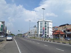
Rengit is a town and an autonomous sub-district in Mukim Sungai Kluang, Batu Pahat District, Johor, Malaysia. Rengit has more than 30 villages and 25 schools.
Geography

The town spans over an area of 6.5 km. The area of Rengit sub-district is approximately 100.8 square miles or 64,512 hectares and divided into 3 mukims namely the Kampung Bahru, Sungai Punggur and Sungai Kluang District where each mukim is governed by a Chief.
Demographic
The Malays are the largest ethnic group in Rengit but there is also a significant Javanese, Chinese and Indian minority as well. The people in Rengit have their own unique dialect of Johor Malay.
Languages
Malay is the most widely spoken language in Rengit and is the native language of the Malays as well as the main lingua franca for inter-ethnic communications. The Chinese usually speak Hokkien and Mandarin amongst themselves while Indians spoke Tamil as their native language.
Education
- SMK Tun Sardon
- SMK Rengit / SMK Permata Jaya
- S.B.R. Chong Hwa High School
- Sekolah Jenis Kebangsaan (C) Chong Hwa Rengit / Chong Hwa Rengit Primary School
Religion
The majority population practice Islam, followed by Chinese folk religion (including Taoism), Buddhism and Christianity.
Place of worship
- Masjid Jamek Rengit
- Tokong Sembilan Maharaja Dewa (龍引斗母宫), founded in 1912
- Rengit Zheng Long Gong Temple (龍引鎮龍宮)
- Rengit Presbyterian Church
Notable residents
- Sardon Jubir, Politician
- Hasanuddin Mohd Yunus, Politician
Neighbouring towns
| Destinations from Rengit | ||||||||||||||||
|---|---|---|---|---|---|---|---|---|---|---|---|---|---|---|---|---|
| ||||||||||||||||
References
- "Profil Daerah". ptj.johor.gov.my.
- Khairul Faizi A Rahman (2014). Parishes Short Info Data of Batu Pahat District. Wow Eight. p. 7.
- Handbook johor.gov.my
- "Profil Daerah". Retrieved 22 May 2018.
| State of Johor | |||||||||||||||
|---|---|---|---|---|---|---|---|---|---|---|---|---|---|---|---|
| |||||||||||||||
| General topics |
|  | |||||||||||||
| Administrative divisions |
| ||||||||||||||
| City councils (Majlis Bandaraya) |
| ||||||||||||||
| Municipal councils (Majlis Perbandaran) |
| ||||||||||||||
| District councils (Majlis Daerah) |
| ||||||||||||||
This Johor location article is a stub. You can help Misplaced Pages by expanding it. |