| Shalanky | |
|---|---|
| Village | |
 Coat of arms Coat of arms | |
 | |
| Coordinates: 48°13′40″N 22°53′2″E / 48.22778°N 22.88389°E / 48.22778; 22.88389 | |
| Country | |
| Oblast | |
| Raion | |
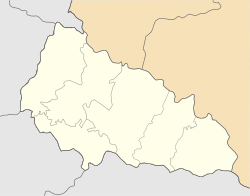
Shalanky (Ukrainian: Шаланки, Hungarian: Salánk) is a village in western Ukraine, within Berehove Raion of Zakarpattia Oblast, but was formerly administered as part of Vynohradiv Raion.
Geography
The village is located around 16 km northwest of Vynohradiv on the bank of the brook Borzsa. Administratively, the village belongs to the Berehove Raion, Zakarpattia Oblast.
Population
The population includes 3110 inhabitants, mostly Hungarians, with a density of 0,280 people / km
Notes
- "Shalanki, Ukraine - Geographical Names, map, geographic coordinates".
- "Офіційний портал Верховної Ради України". w1.c1.rada.gov.ua. Archived from the original on 2013-12-02.
This article about a location in Zakarpattia Oblast is a stub. You can help Misplaced Pages by expanding it. |