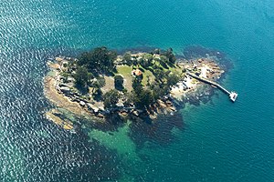
Shark Island is an island located within Sydney Harbour, in New South Wales, Australia. The island is 1.5 hectares (3.7 acres) in area, measuring some 250 metres by 100 metres, and lies off the Sydney suburbs of Point Piper, Rose Bay and Vaucluse, in the eastern section of the harbour between the Harbour Bridge and the harbour entrance. The island was known by the local Aboriginal people as Boambilly, and the current name comes from its shape, which is claimed to resemble a shark. Shark Island Light is an active pile lighthouse located just north of Shark Island, an island in Sydney Harbour, New South Wales, Australia. Its light is only visible on in the fairway of the harbour, between Shark Point and Point Piper.
History

The island has been the site of drownings, shipwrecks, and at least one shark attack. In 1877, Australian rules footballer and cricketer George Coulthard, while sitting in a boat anchored offshore, was pulled overboard by a large shark. Coulthard managed to return to the boat, and his attack and escape were widely reported.
Parts of the island were set aside as a recreation reserve as early as 1879. It was also used as an animal quarantine station and naval depot until 1975. At that time it became exclusively a recreation reserve and part of the Sydney Harbour National Park. Approved operators and a scheduled ferry service can take people to the island.
Archaeologist Mary Harfield was born on the island.
See also
- Bradleys Head
- Clark Island (New South Wales)
- Dobroyd Head
- Goat Island
- Sow and Pigs Reef
- Sydney Heads
- Sydney Harbour National Park
References
- "Sydney Harbour National Park Shark Island". National Parks and Wildlife Service. NSW Government. Retrieved 14 September 2014.
- Shark Island, Dictionary of Sydney. Retrieved 6 June 2016.
- Sydney Harbour National Park - Park Maps Archived 2007-02-08 at the Wayback Machine, New South Wales Department of Infrastructure, Planning and Natural Resources (as at 9 September 2005)
- Searle, Garry. "List of Lighthouses - New South Wales". Lighthouses of Australia. SeaSide Lights.
- Sydney Harbour National Park Culture & history Archived 2005-08-30 at the Wayback Machine, National Parks and Wildlife Service (as at 21 March 2006)
- New weekend ferry service for Sydney Harbour's Shark Island Archived 2007-10-11 at the Wayback Machine, National Parks and Wildlife Service press release 11 April 2003
- David Messent (1994). The Complete Guide to Sydney Harbour, ISBN 0-646-17888-1, page 130.
- Hull, Linda (10 September 2018). "Mary Harfield - Trowelblazers". Retrieved 25 July 2024.
External links
- Catie Gilchrist (2014). "Shark Island". Dictionary of Sydney. Dictionary of Sydney Trust. Retrieved 6 October 2015.
33°51′30.08″S 151°15′27.50″E / 33.8583556°S 151.2576389°E / -33.8583556; 151.2576389
| Islands of Sydney Harbour catchment | |
|---|---|
| Sydney Harbour | |
| Parramatta River | |
| Italics = former island | |
This article related to the geography of Sydney is a stub. You can help Misplaced Pages by expanding it. |
