Map all coordinates using OpenStreetMap
Download coordinates as:
Suburb of Cairns, Queensland, Australia| Trinity Beach Cairns, Queensland | |||||||||||||||
|---|---|---|---|---|---|---|---|---|---|---|---|---|---|---|---|
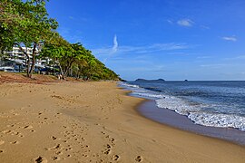
 Trinity Beach looking north Trinity Beach looking north | |||||||||||||||
 | |||||||||||||||
| Coordinates | 16°47′36″S 145°41′48″E / 16.7933°S 145.6966°E / -16.7933; 145.6966 (Trinity Beach (centre of suburb)) | ||||||||||||||
| Population | 6,594 (2021 census) | ||||||||||||||
| • Density | 767/km (1,986/sq mi) | ||||||||||||||
| Postcode(s) | 4879 | ||||||||||||||
| Area | 8.6 km (3.3 sq mi) | ||||||||||||||
| Time zone | AEST (UTC+10:00) | ||||||||||||||
| Location |
| ||||||||||||||
| LGA(s) | Cairns Region | ||||||||||||||
| State electorate(s) | Barron River | ||||||||||||||
| Federal division(s) | Leichhardt | ||||||||||||||
| |||||||||||||||
Trinity Beach is a coastal suburb of Cairns in the Cairns Region, Queensland, Australia. In the 2021 census, Trinity Beach had a population of 6,594 people.
Geography


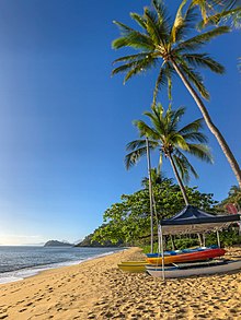
Trinity Beach is approximately 20 kilometres (10 mi) from the Cairns city centre and approximately 6.6 km from Smithfield. Trinity Beach is also a beach stretching for about a mile on the eastern coast of Australia bounded by the Coral Sea. The suburb itself is approximately 2 km wide.
History

Trinity Beach is situated in the Djabugay (Tjapukai) traditional Aboriginal country.
The origin of the suburb name is derived from Trinity Bay.
From 1943 to 1944, Trinity Beach was the site of intensive training in amphibious warfare for Australian and American troops in the context of World War II.
Trinity Beach State School opened on 30 January 1979.
As part of Mulgrave Shire, Trinity Beach experienced suburban development beginning in the 1970s, leading to a population of over 2000 by the mid-1980s.
Trinity Beach became part of the new City of Cairns with the amalgamation of Mulgrave Shire into the new city on 22 March 1995.
In 2000, Cyclone Steve, which made landfall in the Cairns northern beaches area near Trinity Beach, caused significant damage to the roof of the Trinity Beach Hotel.
From 2004 to 2008, the 173-ha Bluewater subdivision, which extends through both Trinity Beach and Trinity Park, was approved for development. As with several other areas in Trinity Beach, portions of the estate sit in a flood zone due to potential inflows from Moore's Gully, which led to a substantial flooding mitigation project for the development in 2010.

In 2023, Trinity Beach was affected by Cyclone Jasper and the resulting 2023 Cairns floods. On 13 December, as the cyclone made landfall, the Trinity Beach waterfront experienced a storm surge event, while soon after overnight, multiple waterfront businesses were vandalised and looted.
On the morning of 17 December, like other Cairns northern beaches suburbs, Trinity Beach experienced flooding. This flooding led to an evacuation warning for the Bluewater Estate and major road closures, which resulted in isolation from the rest of Cairns. Videos on social media soon emerged showing inundated residential neighbourhoods in the suburb. The beach itself was thickly covered with debris in the aftermath of the flooding.
Ahead of the 2024 Queensland state election, preservation of Taylor Point, a scenic, undeveloped part of the Trinity Beach waterfront, became a point of contention as local election candidates pushed for public acquisition. The property was privately acquired in early October 2024, after which Queensland Labor Party threatened compulsory acquisition of the property.
Demographics
In the 2011 census, Trinity Beach had a population of 4,734 people.
In the 2016 census, Trinity Beach had a population of 5,488 people.
In the 2021 census, Trinity Beach had a population of 6,594 people.
Education
Trinity Beach State School is a government primary (Prep-6) school for boys and girls at Wewak Street (16°47′41″S 145°41′22″E / 16.7948°S 145.6895°E / -16.7948; 145.6895 (Trinity Beach State School)). It includes a special education program. In 2016, the school had an enrolment of 923 students with 60 teaching staff (57 full-time equivalent) and 36 non-teaching staff (22 full-time equivalent). In 2018, the school had an enrolment of 1,027 students with 68 teachers (64 full-time equivalent) and 49 non-teaching staff (32 full-time equivalent).
There are no secondary schools in Trinity Beach. The nearest government secondary school is Smithfield State High School in neighbouring Smithfield to the south.
Amenities
Trinity Beach Community Hall is at 51 Trinity Beach Road (16°47′22″S 145°41′39″E / 16.78940°S 145.69424°E / -16.78940; 145.69424 (Trinity Beach Community Hall)). As at April 2024, a new community hall is under construction by the Cairns Regional Council.
References
- ^ Australian Bureau of Statistics (28 June 2022). "Trinity Beach (SAL)". 2021 Census QuickStats. Retrieved 28 February 2023.

- "Trinity Beach – suburb (entry 48906)". Queensland Place Names. Queensland Government. Retrieved 10 April 2016.
- "Trinity Beach – beach (entry 41949)". Queensland Place Names. Queensland Government. Retrieved 10 April 2016.
- "First people cultural history". Cairns Regional Council. Archived from the original on 9 April 2020. Retrieved 23 June 2020.
- "T Suburbs" (PDF). Cairns Regional Council. Retrieved 23 June 2020.
- "Beaches". Cairns Regional Council. 5 October 2021. Archived from the original on 27 December 2023. Retrieved 27 December 2023.
- Queensland Family History Society (2010), Queensland schools past and present (Version 1.01 ed.), Queensland Family History Society, ISBN 978-1-921171-26-0
- "Trinity Beach". Centre for the Government of Queensland. Archived from the original on 27 December 2023. Retrieved 27 December 2023.
- "Mulgrave Shire". Archived from the original on 27 December 2023. Retrieved 27 December 2023.
- "Mulgrave Shire Council". Queensland Government. Archived from the original on 27 December 2023. Retrieved 27 December 2023.
- Callaghan, J. 2003. The Tropical Cyclone Risk in Cairns. Natural Hazards 30, 129-153.
- "Australia's worst cyclones". The Daily Telegraph. Retrieved 27 December 2023.
- "Multiplex Development and Opportunity Fund" (PDF). Archived (PDF) from the original on 16 May 2024. Retrieved 27 December 2023.
- "Queensland Government ArchivesSearch". Queensland Government. Archived from the original on 27 December 2023. Retrieved 27 December 2023.
- "Predictive flood inundation maps". Cairns Regional Council. 5 October 2021. Archived from the original on 27 December 2023. Retrieved 27 December 2023.
- "Tropical Sustainable Design Case Studies: Moore's Gully" (PDF). James Cook University. Archived (PDF) from the original on 27 December 2023. Retrieved 27 December 2023.
- "Jasper's Fury: Far North Queensland reels from widespread flooding". The Courier-Mail. Archived from the original on 27 December 2023. Retrieved 27 December 2023.
- "Police increase patrols in cyclone-affected areas after thefts". Nine News. 14 December 2023. Archived from the original on 14 December 2023. Retrieved 27 December 2023.
- "Break and enters, Trinity Beach and Palm Cove". 14 December 2023. Archived from the original on 27 December 2023. Retrieved 27 December 2023.
- "Emergency Alert for Bluewater Estate". Archived from the original on 27 December 2023. Retrieved 27 December 2023.
- "Leave Immediately – Blue Water Estate". Archived from the original on 27 December 2023. Retrieved 27 December 2023.
- "Cairns Disaster Dashboard". Cairns Regional Council. Archived from the original on 17 December 2023. Retrieved 17 December 2023.
- "Cairns cut off by floodwaters, towns evacuated and drinking water at risk as former Cyclone Jasper continues to devastate". ABC News. 16 December 2023. Archived from the original on 16 December 2023. Retrieved 27 December 2023.
- "Stranded residents face isolation in flood-hit Cairns". Special Broadcasting Service. Retrieved 27 December 2023.
- Cassidy, Caitlin; Wind, Emily; Wind (Earlier), Emily (18 December 2023). "December rainfall records smashed – as it happened". The Guardian. Retrieved 27 December 2023.
- Healy, Samantha (9 October 2024). "Community concerns after Taylor Point at Trinity Beach sold in secret deal". The Cairns Post. Archived from the original on 9 November 2024. Retrieved 9 November 2024.
- Testa, Christopher (12 October 2024). "Queensland Labor threatens compulsory acquisition of Taylor Point after sale to inventor". Archived from the original on 9 November 2024. Retrieved 9 November 2024.
- Australian Bureau of Statistics (31 October 2012). "Trinity Beach (SSC)". 2011 Census QuickStats. Retrieved 5 March 2018.

- Australian Bureau of Statistics (27 June 2017). "Trinity Beach (SSC)". 2016 Census QuickStats. Retrieved 20 October 2018.

- ^ "State and non-state school details". Queensland Government. 9 July 2018. Archived from the original on 21 November 2018. Retrieved 21 November 2018.
- "Trinity Beach State School". Trinity Beach State School. 29 November 2020. Retrieved 23 August 2023.
- "Annual Report 2016" (PDF). Trinity Beach State School. Archived (PDF) from the original on 4 March 2018. Retrieved 5 March 2018.
- "ACARA School Profile 2018". Australian Curriculum, Assessment and Reporting Authority. Archived from the original on 27 August 2020. Retrieved 28 January 2020.
- "Queensland Globe". State of Queensland. Retrieved 23 August 2023.
- "Community Halls". Cairns Regional Council. 30 May 2022. Archived from the original on 29 March 2024. Retrieved 24 April 2024.
External links
- "Trinity Beach". Queensland Places. Centre for the Government of Queensland, University of Queensland.