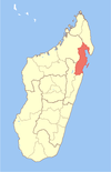
| Vavatenina District | |
|---|---|
 | |
| Coordinates: 17°31′S 48°57′E / 17.517°S 48.950°E / -17.517; 48.950 | |
| Country | |
| Region | Analanjirofo |
| District | Vavatenina |
| Area | |
| • Total | 2,926 km (1,130 sq mi) |
| Elevation | 549 m (1,801 ft) |
| Population | |
| • Total | 202,529 |
| • Density | 69/km (180/sq mi) |
| Time zone | UTC3 (EAT) |
| Postal code | 518 |
Vavatenina District is a district of northeast Madagascar. It is part of the Analanjirofo Region. The district has an area of 2,671 km (1,031 sq mi), and the estimated population in 2020 was 202,529.
Communes
The district is further divided into 11 communes:
- Ambatoharanana
- Ambodimangavalo
- Ambohibe
- Ampasimazava
- Andasibe
- Anjahambe
- Maromitety
- Miarinarivo
- Sahatavy
- Tanamarina
- Vavatenina
Rivers
The main river is the Maningory River.
Roads
The capital of the district, Vavatenina is situated at 45 km from Fénérive-Est, by the National Road 5 and National Road 22.
Economy
The region is one of the most important clove growing areas of Madagascar.
References
- Estimated based on DEM data from Shuttle Radar Topography Mission
- "Ambatondrazaka (District, Madagascar) - Population Statistics, Charts, Map and Location". www.citypopulation.de. Retrieved 2024-01-17.
- Cartographie District Vavatenina
| Capital: Fenoarivo Atsinanana | ||
| Fenerive Est (509) |  | |
| Mananara Nord (511) | ||
| Maroantsetra (512) | ||
| Sainte Marie (Nosy Boraha) (515) | ||
| Soanierana Ivongo (516) | ||
| Vavatenina (518) | ||
| 6 districts; 71 communes | ||
This Analanjirofo location article is a stub. You can help Misplaced Pages by expanding it. |