| Włochy | |
|---|---|
| Warsaw District | |
 Coat of arms Coat of arms Brandmark Brandmark | |
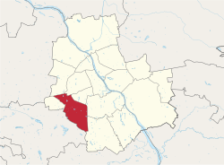
 Location of Włochy within Warsaw Location of Włochy within Warsaw | |
| Coordinates: 52°12′N 20°55′E / 52.200°N 20.917°E / 52.200; 20.917 | |
| Country | |
| Voivodeship | Masovian |
| County/City | Warsaw |
| Notable landmarks | Warsaw Chopin Airport |
| Government | |
| • Mayor | Jarosław Karcz |
| Area | |
| • Total | 28.63 km (11.05 sq mi) |
| Population | |
| • Total | 42,862 |
| Time zone | UTC+1 (CET) |
| • Summer (DST) | UTC+2 (CEST) |
| Area code | +48 22 |
| Website | ud-wlochy.waw.pl |
Włochy (Polish pronunciation: [ˈvwɔxɨ] ) is one of the districts of Warsaw, located in the south-western part of city. Włochy borders districts Bemowo and Wola from the north, Ochota and Mokotów from the east, and Ursus and Ursynów from the south. It is one of 3 neighborhoods with the title of a garden town (pol. Miasto-Ogród Włochy).
History
In the 14th century the area contained multiple farming villages, the names of which remain as neighborhood names within the district (eg. Raków, Zbarż, Szczęśliwice). The most notable of these was Porzucewo, which was in 1452 bought by Jan Włoch. After his death in the early 16th century the village's name was changed to Włochy in his honor.
In the 17th century the villages were again bought and developed by Andrzej Leszczyński, an archbishop and the Royal Chancellor as a summer residence. His palace was pillaged and destroyed during the Swedish Deluge. Later the village remained in noble hands as a vacation property, most notably to the Mostowski and Koelichen families, who erected a small palace which today is home to a public library.
During the industrial age the area was used for brick production and clay mining (supplying the neighboiring Ursus factory town). The remnants of old mines were flooded and are now public ponds used for recreation and as home for birds and fish.
Between 1938 and 1951 Włochy had town privileges. On 2 May 1951 Włochy was annexed into Warsaw as part of the Ochota district. Since 1994 it has formed the Warszawa-Włochy municipality. In 2002 the municipality became an independent district of Warsaw.
Name
The name Włochy is grammatically plural and in the nominative is identical to the polish term for the country of Italy (pol. Włochy), although they differ in other grammatical cases (eg. gen. Włoch v Włochów). It most likely comes from the pseudonym of one of the numerous villages' owners in the mid 15th century - Jan Włoch. This pseudonym could either refer to the country of Italy or could signify the man's hairy appearance (pol. włochy - colloq. thick, long hairs). Too little is known about this person to rule out either possibility. There exist other name origin theories, mainly referring to the Italian army possibly stationed here during the 18th and 19th centuries. These claims, however, are negated by historians because the name has been in use for at least 300 years before those times. The citizen of Włochy is called Włochowianin.
Neighbourhoods within the district
- Nowe Włochy
- Okęcie
- Jadwisin
- Zbarż
- Opacz Wielka
- Paluch
- Gorzkiewki
- Raków
- Wiktoryn
- Salomea
- Stare Włochy
- Solipse
- Budki Szczęśliwickie
- Załuski
References
- "Powierzchnia i ludność w przekroju terytorialnym w 2019 roku. Tabl. 21 Powierzchnia, ludność oraz lokaty według gmi". stat.gov.pl. Główny Urząd Statystyczny. Retrieved 2 September 2020.
- "Historia Dzielnicy Włochy". 2021.
External links
| Inner city districts |
| ||||||||||||||||||||||
|---|---|---|---|---|---|---|---|---|---|---|---|---|---|---|---|---|---|---|---|---|---|---|---|
| Outer city districts |
| ||||||||||||||||||||||
| Related | |||||||||||||||||||||||
| Włochy | ||
|---|---|---|
This Warsaw-related location article is a stub. You can help Misplaced Pages by expanding it. |