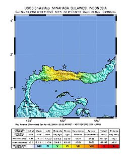
 | |
  | |
| UTC time | 2008-11-16 17:02:32 |
|---|---|
| ISC event | 11453303 |
| USGS-ANSS | ComCat |
| Local date | November 17, 2008 (2008-11-17) |
| Local time | 01:02 |
| Magnitude | 7.4 Mw |
| Depth | 21 km (13 mi) |
| Epicenter | 1°17′N 122°04′E / 1.29°N 122.07°E / 1.29; 122.07 |
| Areas affected | Indonesia |
| Max. intensity | MMI VII (Very strong) |
| Casualties | 4 killed, 59 injured |
The 2008 Sulawesi earthquake struck Sulawesi, Indonesia, on 16 November at 17:02:31 UTC. A 7.4 Mw earthquake, it was followed by seven aftershocks higher than 5.0 Mw . Tsunami warnings were issued for the region, but later cancelled. Four people were killed in the quake and 59 injured.
Effects
The earthquake caused four fatalities and nearly 60 injuries. Over 700 houses were destroyed, and several buildings collapsed, one of which killed a man in the city of Gorontalo. The assessment of damage in rural areas with unreliable communication led officials to believe that the extent of the damage was greater than their initial evaluations.
See also
References
- ^ "Four killed in Indonesia quake". Australian Broadcasting Corporation. November 17, 2008. Retrieved 2008-11-21.
- "Magnitude 7.3 – MINAHASA, SULAWESI, INDONESIA". United States Geological Survey. November 16, 2008. Archived from the original on 2 December 2008. Retrieved 2008-11-16.
- ^ "Four killed in Indonesia quake". Australia: ABC News. 2008-11-17. Retrieved 2015-09-15.
External links
- The International Seismological Centre has a bibliography and/or authoritative data for this event.
| ← Earthquakes in 2008 → | |
|---|---|
| February |
|
| April |
|
| May |
|
| June |
|
| July |
|
| August | |
| September |
|
| October |
|
| November |
|
| December |
|
| † indicates earthquake resulting in at least 30 deaths ‡ indicates the deadliest earthquake of the year | |