 | |
| UTC time | Doublet earthquake: |
|---|---|
| 1943-06-08 20:42:46 | |
| 1943-06-09 03:06:20 | |
| ISC event | |
| 899871 | |
| 899872 | |
| USGS-ANSS | |
| ComCat | |
| ComCat | |
| Local date | June 9, 1943 |
| Local time | |
| 03:42:46 | |
| 10:06:20 | |
| Magnitude | |
| Ms 7.5 | |
| Ms 7.8 | |
| Depth | 15 km (9.3 mi) 10 km (6.2 mi) |
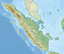
| Epicenter | 1°00′S 101°00′E / 1.0°S 101.0°E / -1.0; 101.0 |
| Areas affected | Indonesia |
| Max. intensity | IX (Destructive) (both events) |

The 1943 Alahan Panjang earthquakes occurred on June 8 and June 9 UTC (June 9, 1943, local time) in Sumatra, then under Japanese occupation. This was an earthquake doublet (the shocks occurred at the same location on consecutive days).
The first mainshock occurred on June 8 at 20:42 UTC. It ruptured the Suliti segment of the Sumatran Fault Zone. The magnitude was given as Mw 7.2, or Ms 7.1.
The second mainshock occurred on June 9 at 03:06 UTC. It ruptured the Sumani segment of the Sumatran Fault Zone and perhaps the northwestern part of the Suliti segment. The magnitude was given as Mw 7.5, or Ms 7.4.
Alahan Panjang was damaged in the earthquakes. Right lateral offsets were reported near the town of Solok.
Near the Sumani segment, earthquake doublets occurred repeatedly. Similar earthquake doublet nearby include the earthquakes in 1926 and 2007.
See also
References
- ^ Engdahl, E. R.; Vallaseñor, A. (2002). "Global seismicity: 1900–1999" (PDF). International Handbook of Earthquake & Engineering Seismology. Part A, Volume 81A (First ed.). Academic Press. p. 678. ISBN 978-0124406520.
- ^ ISC-OB Event 899871 [IRIS].
- ^ ISC-OB Event 899872 [IRIS].
- Martin, S. S.; Cummins, P. R.; Meltzner, A. J. (2022), "Gempa Nusantara: A Database of 7380 Macroseismic Observations for 1200 Historical Earthquakes in Indonesia from 1546 to 1950", Bulletin of the Seismological Society of America, 112 (6): 2958–2980, Bibcode:2022BuSSA.112.2958M, doi:10.1785/0120220047, hdl:10356/166257, ISSN 0037-1106, S2CID 253365854
- ^ Natawidjaja, D. H.; Triyoso, W. (2007), "The Sumatran Fault Zone – from Source to Hazard", Journal of Earthquake and Tsunami, 01: 21, doi:10.1142/S1793431107000031
- ^ Natawidjaja, D. H. (2003), Neotectonics of the Sumatran fault and paleogeodesy of the Sumatran subduction zone (phd), Dissertation (Ph.D.), California Institute of Technology, Bibcode:2003PhDT.........7N, doi:10.7907/KBXR-5B89
- Nakano, M.; Kumagai, H.; Toda, S.; Ando, R.; Yamashina, T.; Inoue, H.; Sunarjo (2010), "Source model of an earthquake doublet that occurred in a pull-apart basin along the Sumatran fault, Indonesia", Geophysical Journal International, 181 (1): 141–153, Bibcode:2010GeoJI.181..141N, doi:10.1111/j.1365-246X.2010.04511.x
- Aydan, Ö. (2007), A reconnaissance report on the 2007 Singkarak Lake (Solok) earthquake with and emphasis on the seismic activity of Sumatra Fault following the 2004 and 2005 great off-Sumatra earthquakes (PDF), Japan Society of Civil Engineers
External links
- The International Seismological Centre has a bibliography and/or authoritative data for this event.
| Earthquakes in the 1940s | |
|---|---|
| 1940 |
|
| 1941 |
|
| 1942 |
|
| 1943 |
|
| 1944 |
|
| 1946 |
|
| 1947 | |
| 1948 |
|
| 1949 |
|
| † indicates earthquake resulting in at least 30 deaths ‡ indicates the deadliest earthquake of the year | |