Human settlement in England
| Haltham | |
|---|---|
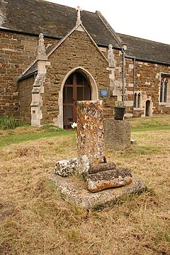
 Churchyard cross and St Benedict's Church, Haltham Churchyard cross and St Benedict's Church, Haltham | |
 | |
| Population | 122 (2011) |
| OS grid reference | TF247637 |
| • London | 110 mi (180 km) S |
| Civil parish |
|
| District | |
| Shire county | |
| Region | |
| Country | England |
| Sovereign state | United Kingdom |
| Post town | HORNCASTLE |
| Postcode district | LN9 |
| Dialling code | 01507 |
| Police | Lincolnshire |
| Fire | Lincolnshire |
| Ambulance | East Midlands |
| UK Parliament | |
| |
Haltham is a village and civil parish in the East Lindsey district of Lincolnshire, England. The population of the civil parish at the 2011 census was 122. It is situated 4 miles (6.4 km) south from the town of Horncastle, and on the east bank of the River Bain in the Lincolnshire Wolds, a designated Area of Outstanding Natural Beauty.
History
Main article: St Benedict's Church, Haltham-on-BainHaltham is listed in the Domesday Book of 1086 as "Holtha", with 15 households, and King William I as Lord of the Manor.
Church
The parish church was dedicated to Saint Benedict, and is a Grade I listed building built of greenstone and red-brick dating from the 12th century, with restorations in 1881 and 1890. In 1964 Pevsner noted a chalice and flagon, dated 1765, by London silversmith Francis Crump. The church was closed by the Diocese of Lincoln in October 1977, and is now maintained by the Churches Conservation Trust.
In the churchyard is the base of a 14th-century cross which is Grade II listed and also a scheduled monument.
Geography
The village was served by the Marmion Arms public house, a half-timbered thatched building.
In 1885 Kelly's Directory recorded that agricultural production in the then 2,380 acres (9.6 km) acre parish was chiefly wheat, oats and turnips, The 1881 population was 179.
References
- "Haltham (Parish): Key Figures for 2011 Census". Neighbourhood Statistics. Office for National Statistics. Retrieved 19 May 2016.
- "Domesday Map". Haltham. Anna Powell-Smith/University of Hull. Retrieved 19 June 2011.
- Pevsner, Nikolaus; Harris, John; The Buildings of England: Lincolnshire p. 265; Penguin (1964); revised by Nicholas Antram in 1989, Yale University Press. ISBN 0-300-09620-8
- "Haltham". Genuki.org.uk. Retrieved 19 June 2011.
- Historic England. "St Benedict Haltham (352856)". Research records (formerly PastScape). Retrieved 19 June 2011.
- "British Listed Buildings". St Benedict Haltham. English Heritage. Retrieved 19 June 2011.
- "British Listed Buildings". cross, Haltham. English Heritage. Retrieved 19 June 2011.
- Historic England. "Churchyard cross, St Benedict's churchyard (1010680)". National Heritage List for England. Retrieved 17 June 2017.
- "Lincs to the Past". Marmion Arms, Haltham. Lincolnshire Archives. Retrieved 19 June 2011.
- Kelly's Directory of Lincolnshire with the port of Hull 1885, p. 464
External links
 Media related to Haltham at Wikimedia Commons