| This article needs additional citations for verification. Please help improve this article by adding citations to reliable sources. Unsourced material may be challenged and removed. Find sources: "West Ashby" – news · newspapers · books · scholar · JSTOR (April 2011) (Learn how and when to remove this message) |
Human settlement in England
| West Ashby | |
|---|---|
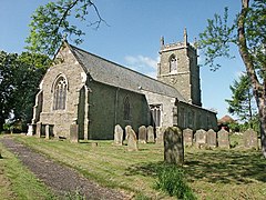
 All Saints' Church, West Ashby All Saints' Church, West Ashby | |
 | |
| Population | 252 (2011) |
| OS grid reference | TF265723 |
| • London | 120 mi (190 km) S |
| Civil parish |
|
| District | |
| Shire county | |
| Region | |
| Country | England |
| Sovereign state | United Kingdom |
| Post town | HORNCASTLE |
| Postcode district | LN9 |
| Dialling code | 01507 |
| Police | Lincolnshire |
| Fire | Lincolnshire |
| Ambulance | East Midlands |
| UK Parliament | |
| |
West Ashby is a village and civil parish in the East Lindsey district of Lincolnshire, England. It is situated on the Horncastle to Louth A153 road, and 2 miles (3.2 km) north from the centre of Horncastle. Farthorpe, Middlethorpe, and Furzehills are hamlets within the parish. According to the 2001 Census, and 2011 Census, West Ashby had a population of 252.
The name 'Ashby' derives from the Old Norse askr-by meaning 'ash tree farm/settlement'. The remains of a henge monument can be found just west of the village, off Docking Lane. Furze Hills is the site of the plague village of Northorpe.
All Saints parish church was extensively restored between 1848 and 1873.
Horncastle's golf club is located at West Ashby Country Park, where Shearman's Wath road crosses the River Bain.
References
- "Parish population 2001 & 2011". Retrieved 22 August 2015.
- "Key to English Place-names". Key to English Place-names. Retrieved 26 January 2023.
- "History Detail".
External links
 Media related to West Ashby at Wikimedia Commons