| This article relies largely or entirely on a single source. Relevant discussion may be found on the talk page. Please help improve this article by introducing citations to additional sources. Find sources: "Mont Caro" – news · newspapers · books · scholar · JSTOR (November 2021) |
| Mont Caro | |
|---|---|
 | |
| Highest point | |
| Elevation | 1,441 m (4,728 ft) |
| Listing | Mountains of Catalonia |
| Coordinates | 40°48′11.18″N 0°20′35.13″E / 40.8031056°N 0.3430917°E / 40.8031056; 0.3430917 |
| Geography | |
  | |
| Parent range | Ports de Tortosa-Beseit |
| Geology | |
| Mountain type | Karstic |
| Climbing | |
| Easiest route | Driving from Tortosa |
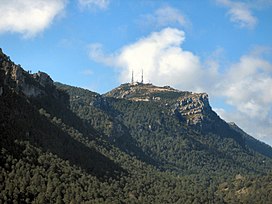
Mont Caro (Catalan pronunciation: [ˈmoŋ ˈkaɾu]) or Caro is the highest mountain of the Ports de Tortosa-Beseit, Catalonia, Spain.
Geography
It has an elevation of 1,441 metres above sea level. There are two large antennas and a Virgin Mary shrine on top of the summit.
This mountain is often covered with snow in the winter.
See also
References
- "Mapa Topogràfic de Catalunya". Institut Cartogràfic de Catalunya. Retrieved May 22, 2010..
This article about a location in Catalonia is a stub. You can help Misplaced Pages by expanding it. |