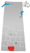
Ormiston is an organized hamlet in Excel Rural Municipality No. 71, Saskatchewan, Canada. The population was 25 at the 2011 Census. It is located in the south-central portion of the province, south of the city of Moose Jaw.
Demographics
In the 2021 Census of Population conducted by Statistics Canada, Ormiston had a population of 10 living in 6 of its 11 total private dwellings, a change of 0% from its 2016 population of 10. With a land area of 0.35 km (0.14 sq mi), it had a population density of 28.6/km (74.0/sq mi) in 2021.
Canada census – Ormiston, Saskatchewan community profile| 2011 | |
|---|---|
| Population | 25 (66.7% from 2006) |
| Land area | 0.34 km (0.13 sq mi) |
| Population density | 74.4/km (193/sq mi) |
| Median age | |
| Private dwellings | 13 (total) |
| Median household income |
Climate
| Climate data for Ormiston | |||||||||||||
|---|---|---|---|---|---|---|---|---|---|---|---|---|---|
| Month | Jan | Feb | Mar | Apr | May | Jun | Jul | Aug | Sep | Oct | Nov | Dec | Year |
| Record high °C (°F) | 11 (52) |
17 (63) |
22.8 (73.0) |
31.5 (88.7) |
37 (99) |
40 (104) |
39 (102) |
39 (102) |
37 (99) |
34 (93) |
23.3 (73.9) |
13 (55) |
40 (104) |
| Mean daily maximum °C (°F) | −8.2 (17.2) |
−5 (23) |
1.8 (35.2) |
11.3 (52.3) |
18.6 (65.5) |
23.4 (74.1) |
26.1 (79.0) |
25.5 (77.9) |
19 (66) |
11.9 (53.4) |
1.1 (34.0) |
−5.9 (21.4) |
10 (50) |
| Daily mean °C (°F) | −13.6 (7.5) |
−10.4 (13.3) |
−3.5 (25.7) |
4.9 (40.8) |
11.9 (53.4) |
16.7 (62.1) |
19.2 (66.6) |
18.4 (65.1) |
12.2 (54.0) |
5.5 (41.9) |
−4 (25) |
−11.4 (11.5) |
3.8 (38.8) |
| Mean daily minimum °C (°F) | −18.9 (−2.0) |
−15.6 (3.9) |
−8.8 (16.2) |
−1.5 (29.3) |
5.2 (41.4) |
10 (50) |
12.3 (54.1) |
11.2 (52.2) |
5.3 (41.5) |
−0.9 (30.4) |
−9 (16) |
−16.9 (1.6) |
−2.3 (27.9) |
| Record low °C (°F) | −48.3 (−54.9) |
−41 (−42) |
−38.3 (−36.9) |
−28.9 (−20.0) |
−11.7 (10.9) |
−5 (23) |
2.8 (37.0) |
0 (32) |
−7.8 (18.0) |
−23 (−9) |
−35 (−31) |
−43.5 (−46.3) |
−48.3 (−54.9) |
| Average precipitation mm (inches) | 11 (0.4) |
9.1 (0.36) |
16.2 (0.64) |
19.2 (0.76) |
49.2 (1.94) |
65.3 (2.57) |
56.1 (2.21) |
41.7 (1.64) |
32.6 (1.28) |
18.2 (0.72) |
10.6 (0.42) |
13 (0.5) |
342.2 (13.47) |
| Source: Environment Canada | |||||||||||||
See also
References
- "Population and dwelling counts: Canada and designated places". Statistics Canada. February 9, 2022. Retrieved August 31, 2022.
- "2011 Community Profiles". 2011 Canadian census. Statistics Canada. March 21, 2019. Retrieved May 27, 2011.
- "2006 Community Profiles". 2006 Canadian census. Statistics Canada. August 20, 2019.
- "2001 Community Profiles". 2001 Canadian census. Statistics Canada. July 18, 2021.
- Environment Canada - Canadian Climate Normals 1971-2000—Canadian Climate Normals 1971–2000, accessed 10 December 2010
| Places adjacent to Ormiston, Saskatchewan | ||||||||||||||||
|---|---|---|---|---|---|---|---|---|---|---|---|---|---|---|---|---|
| ||||||||||||||||
49°44′17″N 105°23′37″W / 49.73806°N 105.39361°W / 49.73806; -105.39361
This article about a location in the Census Division No. 3 of Saskatchewan is a stub. You can help Misplaced Pages by expanding it. |
