| Jeetzel | |
|---|---|
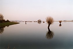
 The Jeetzel as it flows between Seerau and Hitzacker The Jeetzel as it flows between Seerau and Hitzacker | |
| Location | |
| Country | Germany |
| Physical characteristics | |
| Source | |
| • location | Altmark |
| Mouth | |
| • location | Elbe |
| • coordinates | 53°9′26″N 11°2′38″E / 53.15722°N 11.04389°E / 53.15722; 11.04389 |
| Length | 73 km (45 mi) |
| Basin size | 1,919 km (741 sq mi) |
| Basin features | |
| Progression | Elbe→ North Sea |
The river Jeetzel, which begins in the Altmark under the name Jeetze, flows from Saxony-Anhalt through Lower Saxony, in Germany. From its source near the village of Dönitz, it flows north through Beetzendorf, Salzwedel, Wustrow, Lüchow and Dannenberg, before joining the Elbe in Hitzacker. Its total length is 73 kilometres (45 mi).
A left tributary of the Elbe, the Jeetzel has itself several tributaries, including the Salzwedel Dumme and the Wustrow Dumme. The name is Slavic, and means ash (tree)-stream.
Historically, when the Elbe rose too high, it would flooded the Jeetzel, which flowed "backwards" and flooded the surrounding area. Today, a system of canals prevents such flooding.
See also
References
- Environmental map service of Lower Saxony (Umweltkartendienst des Niedersächsischen Ministeriums für Umwelt, Energie und Klimaschutz)
- Hans-Joachim Uhlemann and Martin Eckoldt, Kleine Nebenflüsse der Elbe oberhalb des Tidegebietes, published in Hans-Georg Braun's 1988 Flüsse und Kanäle.
| Baltic Sea | |
|---|---|
| Black Sea | |
| North Sea | |
| Maas | |
This article related to a river in Saxony-Anhalt is a stub. You can help Misplaced Pages by expanding it. |
This article related to a river in Lower Saxony is a stub. You can help Misplaced Pages by expanding it. |