| Aygek Այգեկ | |
|---|---|
 | |
| Coordinates: 40°11′19″N 44°23′00″E / 40.18861°N 44.38333°E / 40.18861; 44.38333 | |
| Country | Armenia |
| Marz (Province) | Armavir |
| Founded | 1946 |
| Area | |
| • Total | 4.26 km (1.64 sq mi) |
| Elevation | 870 m (2,850 ft) |
| Population | |
| • Total | 1,443 |
| Time zone | UTC+4 ( ) |
| • Summer (DST) | UTC+5 ( ) |
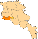
Aygek (Armenian: Այգեկ) is a village and a rural community in the Armavir Province of Armenia. It is located 8 km west of the capital Yerevan and 36 km east of the provincial centre Armavir. It has an elevation of 870 metres above sea level. The majority of the village are Armenian migrants from Iran.
The village is only 16 km away from the Armenian-Turkish border line.
See also
References
- "Armavir (Armenia): Towns and Villages in Municipalities". www.citypopulation.de. Retrieved 2024-11-10.
- Aygek
- Aygek at GEOnet Names Server
- World Gazeteer: Armenia – World-Gazetteer.com
- Report of the results of the 2001 Armenian Census, Statistical Committee of Armenia
- Kiesling, Brady (June 2000). Rediscovering Armenia: An Archaeological/Touristic Gazetteer and Map Set for the Historical Monuments of Armenia (PDF). Archived (PDF) from the original on 6 November 2021.
This article about a location in Armavir Province, Armenia is a stub. You can help Misplaced Pages by expanding it. |
